

Geographical Location
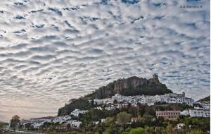 In the heart of the Natural Park of Sierra de Grazalema with a surface area of 71.30 square kilometres, specifically in the north - eastern part of the province of Cádiz, lies Zahara. It is located along the slopes of Sierra del Jaral (Ruta de los Pueblos Blancos). There are wonderful views of its surroundings. In the northern part, we see Algodonales and Sierra de Líjar; Bocaleones river and Sierra Margarita (Prado del Rey and El Bosque) are located in the western part. In the southern part, we see Arroyomolinos, Monte Prieto, Sierra Blanquilla, Puerto de las Palomas and Sierra del Pinar (Grazalema). Finally in the eastern area, we find el Peñón Algarín (El Gastor).
HOW TO GET THERE
By highway:
The main way of getting there is taking the A-382 road (Jerez Fra.- Antequera), which links directly with CA-531 road (Algodonales - Grazalema) and that gives us direct access to the village and the rest of the “Pueblos Blancos” (White Villages). In the same way, A-382 road links with A-473 (Sevilla - Ronda - Costa del Sol) and it directly connects us with Serranía de Ronda and the province of Málaga.
By train:
- Jerez Station
- Cádiz Station
- Seville Station
- Ronda Station
- Málaga Station
By plane:
- Jerez Airport
- Seville Airport
- Málaga Airport